Rhudaur


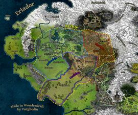
Rhudaur (Sindarin for "Eastern Forests") is the name of one of the three kingdoms into which Arnor was divided in T.A. 861 (the other two being Arthedain and Cardolan). True to its name, Rhudaur was the easternmost division of what was once Arnor, and included the entirety of the Ettenmoors, most of what is now the Trollshaws (west of the River Bruinen), a small part of the North Downs (east of Esteldin) and much of the Lone-lands. The Weather Hills and the Tower of Amon Sûl were highly desired by Rhudaur, whose inhabitants tried to take them by force repeatedly from Arthedain and Cardolan, both of whom also claimed the site as their own. The capital and other big settlements of Rhudaur are never mentioned, but in the game some of these are accesible such as Ost Guruth.
Unlike its sister states of Arthedain and Cardolan, Rhudaur from the start had very few Dúnedain inhabitants, being mostly peopled by hill-men sympathetic to Angmar. It was not long before Rhudaur became a puppet state controlled by the Witch-king of Angmar, and in 1409 an invading force from Angmar destroyed the remaining Dúnedain and ended the kingdom.
The Lord of the Rings Online: Shadows of Angmar references characters who have roots in Rhudaur:
- Ánraig - headed armies against the people of Arthedain
External Links
- Wikipedia: Rhudaur
- TolkienWiki: Rhudaur
- Hinting at Rhudaur: Rhudaur (Oct 21 2022, 11:34 PM @Scenario)
| Regions within the Land of Unannounced Lands
| ||
|---|---|---|
| Adagím • Andrast • Barding-lands • Cape of Eryn Vorn • Dorwinion • Drúwaith Iaur • East Bight • Emyn Beraid (Tower Hills) • Emyn Muil • Ettendales • Far Downs • Fields of Celduin • Forodwaith • Grey Havens (Mithlond) • Himling • Jarmát (Far Harad) • Khand • Lindon (Forlindon (Forlond), Harlindon (Harlond)) • Lâkhedin • Lithlad • Middle Mirkwood • Minhiriath • Mûr Ghala • The Narrows • Nimshatûm • Nindalf • Northern Ered Luin • Nurn • Ordâkh • Rhudaur • Rhûn • Southern Enedwaith (Lond Daer Enedh) • Southern Gondor (Harondor/Damarzâg) • Southfarthing of the Shire • Tolfalas • West-march • Western Enedwaith |