Archival Geography
Jump to navigation
Jump to search

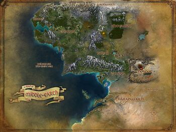
Archival Geography include all places on the map found within the game that are of interest, as the boundaries and borders known as Locations, Interiors, or as Instances. It's a fancy name for what most players refer to as Locations on the Middle-earth Map (see map). Note: Locations are subdivided for ease of navigation.
Locations in hierarchical order
- Regions
- Locations viewed on the second layer of the Middle-earth map; found on the land maps -- (see all Regions)
- Each Region has its own map.
- Examples: Angmar, Dunland, East Rohan, Central Gondor
- Areas
- Locations viewed on the third layer of the Middle-earth map; found on the region maps (these are named places that do not have their own map) -- (all Areas)
- Examples: Redhorn Lodes, Westfold, Pelennor, Agarnaith
- Settlements
- Locations viewed on either the third or fourth layer of the Middle-earth map; found on a region or area map (these are named places that may or may not have their own map) -- (see all Settlements)
- Types of Settlements:
- Examples: Rivendell, Isengard, Edoras, Minas Tirith
- Landmarks
- Locations viewed on the Middle-earth map that represent buildings, structures, city sections, and other noteworthy locations that are of outstanding, historical, aesthetic, or cultural importance which may or may not have a red flag -- (see all Landmarks)
- POIs (red flag) are Landmarks, but some Landmarks do not show flag.
- Examples: Market Square, Lady's Rest, Brandywine Bridge, Bones of Smaug
Locations outside the hierarchy
- Interiors
- Locations that require a character to step into an instance, whether they step through a door into a building or through a cave entrance into a network of tunnels or crypts - (all Interiors)
- Examples: The Forsaken Inn, Lalia's Market, Caves of the Avorrim, Lake-town Trading Hall
- Instances
- Locations that are separate from the world, sometimes duplicate copies of places, which are used for Quest Instances, Skirmishes, Public Dungeons and World Instances - (see all Instances)
- Examples: Goblin-town, Defence of Minas Tirith, The Siege of Gondamon, The Rift of Nûrz Ghâshu (Raid)
- For all landscapes and structures, see Physical Geography
- For all "man-made" (Humanoid) buildings and structures, see Humanoid Geography