Harad
- This page is about the southern lands more historically. For the southern lands as they appear in game, see Haradwaith.
Lore


Harad is the land of the Haradrim, named from the people who live there. Harad, together with its neighbouring coastal nation of Umbar, forms the land of Haradwaith ("South-folk", from the Sindarin harad, "South" and gwaith, "people"). Harad consists of two nations: Shagâna (Near Harad) and Jarmát (Far Harad). The first part of Harad was added to the game with the addition of the Valley of Ikorbân.
These wide sun-baked lands are known to the Hobbits of the Shire as the "Sunlands". The Shire-hobbits know almost nothing about the Sunlands, which remain a place of distant legend to them. They at least understand that a people of the Big Folk live there, whom they refer to as 'Swertings'. They also have folktales of a creature they call an 'Oliphaunt', a remote recollection of the monstrous war-beasts the Haradrim call Mûmakil.
Harad is located south of Gondor and Mordor, with the Mountains of Shadow forming part of its northern border. The River Harnen flows westward from the Mountains of Shadow to the Bay of Belfalas, and is Harad's border with Southern Gondor.
Shagâna - Near Harad
Historically the northern border of Harad was held to be the river Harnen, but by the time of the War of the Ring all the land south of the river Poros was under the influence of the Haradrim. This land was named Harondor, or Southern Gondor.
Shagâna is the part of Harad closest to both Harondor and the Cape of Umbar. The Harad Road runs through here, providing a means of commerce and a route for armies in times of war.
Shagâna is the part of Harad that has the greatest influence over Umbar, over millennia changing the culture there from a Númenórean-based people to a society much more closely linked to the Haradrim of Near Harad.
Jarmát - Far Harad
Jarmát is a much more massive territory, though little is known about it. The landscape is dominated by the Harad Waste, but also consists of crags, valleys and jungles, with its inhabitants living in scattered tribes. Reports from the time of the War of the Ring speak of exceptionally tall dark-skinned men (called Half-trolls) from there who fought for the forces of Mordor.
In the Great Forest of the South in Jarmát live the gigantic animals known as Mûmakil (Mûmak) or Oliphaunts to the Shire Folk, elephant-like but larger and more aggressive. They are used by the Haradrim as moving war towers. Evidently gigantic cousins of the modern elephant, they are also related to the Mammoths. Oliphaunt is a real word from early English.
Harad Road
The Harad Road is the main route linking Gondor and Mordor with Near Harad. It crosses the rivers Poros and Harnen and continues far south into the Haradwaith, serving both trade and military campaigns. During the War of the Ring, Sauron used it to move Haradrim armies northward, and it was along this road in Ithilien that Faramir ambushed a company of Haradrim.
Maps
-
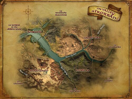 The Valley of Ikorbân, part of Shagâna, is the first part of Harad to be added to the game.
 -
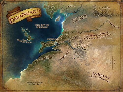 The map of Haradwaith largely covers the land of Harad.
 -
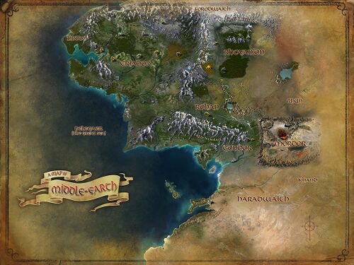 A map of Middle-earth showing Harad in the south.
 -
 Harad still has many named regions that are not yet announced to be added to the game.


References
The Two Towers:
- "The Black Gate Is Closed," p. 247, 249, 254;
- "Of Herbs and Stewed Rabbit," p. 256-59, 267-69;
- "The Window on the West," p. 277;
- "The Forbidden Pool," p. 300-301;
- "Journey to the Cross-roads," p. 303, 310-11
The Return of the King: "The Black Gate Opens," p. 159-63
| Regions within Harad
| ||
|---|---|---|
| In-game: Shagâna: Valley of Ikorbân (Ambarûl • Imhûlar • Khûd Zagin • Urash Dâr) Not yet in-game: Shagâna: Mûr Ghala (Adagím • An Shêru • Idagâl • Kighân) • Lâkhedin • Nimshatûm • Silapesh |