Deed Lore
- Discover the Dwarf Markers spread across the Dwarf-holds.
- Discover the Dwarf Markers spread across the Dwarf-holds (12)
- You have found all of the dwarf-markers in the Dwarf-holds, used by the dwarves of old in surveying the lands for potential mining opportunities.
Rewards
Locations
| Coordinates |
Directions / Description
|
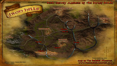
| [22.8N, 16.8W] |
Iron Hills, between the western waterfall and Skald's Drop
|
| [20.5N, 16.3W] |
Iron Hills, northwest of Skald's Drop
|
| [21.5N, 13.1W] |
Iron Hills, southwest of the Dáinlik
|
| [25.5N, 11.7W] |
Iron Hills, above the road between Utterby and Járnfast, south
|
| [26.1N, 12.0W] |
Iron Hills, above the road between Utterby and Járnfast, north
|
| [22.7N, 9.5W] |
Iron Hills, east of the Dáinlik, above the waterfall
|
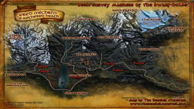
| [35.1N, 39.4W] |
Ered Mithrin, slightly east of Bizar-atrâd
|
| [34.0N, 42.2W] |
Ered Mithrin, next to the Rally Point between Skarháld and Dôm Goru, above the western section of the Bitter Scar
|
| [35.0N, 43.3W] |
Ered Mithrin, top of the hill by the road leading to Stormwall
|
| [32.9N, 47.6W] |
Ered Mithrin, at the top of the hill in Thornholt next to Radagast
|
| [33.8N, 51.8W] |
Ered Mithrin, in the hills north of the road to the Rushgate
|
| [34.6N, 52.2W] |
Ered Mithrin, south of Stánbalk and just slightly northwest of previous marker
|
Maps


