Harad
Lore

Haradwaith or on some maps, Harad, was named from the people who lived there, it literally means "South-folk", from the Sindarin harad, "South" and gwaith, "people". These wide sun-baked lands were known to the Hobbits of the Shire as the "Sunlands".
The Shire-hobbits knew almost nothing about the Sunlands, which were a place of distant legend to them. They at least understood that a people of the Big Folk lived there, who they referred to as 'Swertings'. They also had folktales of a creature they knew as an 'Oliphaunt', a remote recollection of the monstrous war-beasts the Haradrim called Múmakil.
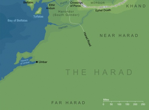
It is located south of Mordor, with the Mountains of Shadow forming part of the northern border of Harad. The River Harnen flowed westward from the Mountains of Shadow to the Bay of Belfalas and was Harad's border with Eastern Gondor.

Near Harad
A deserted region, between the River Poros and the River Harnen, is contested between Gondor and Harad.
- The Harad Road ran from Harad northward through Eastern Gondor and on to South Ithilien.
- Historically the northern border of Haradwaith was held to be the river Harnen, but by the time of the War of the Ring all the land south of the river Poros was under the influence of the Haradrim.
Far Harad
It is a massive territory, yet little is known about the place. The landscape probably consists of jungles and deserts and the inhabitants live in tribes. Reports from the time of the War of the Ring speak of exceptionally tall dark-skinned men (called Half-trolls) from there, fighting for the forces of Mordor.
Located far to the South of Gondor. On the coast there was a natural harbor with a narrow cape curving around it. The coastal region around the harbor was known as Umbar, and the harbor was called the Havens of Umbar. The seafaring raiders known as the Corsairs lived there. At the eastern end of the harbor was the City of the Corsairs.
Much of Far Harad was a jungle, although there also was a desert. In the Great Forest of the South in Far Harad lived the gigantic animals known as Mûmakil (Múmak) or Oliphaunts to the Shire Folk, elephant-like but larger and more aggressive, they were used by the Haradrim as moving war towers. Evidently gigantic cousins of the modern elephant they are related to the Mammoths. Oliphaunt is a real word from ancient English.
Harad Road
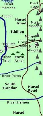
The Harad Road was the continuation of the Southern road of the Crossroad in Ithilien.
The Southern road ran South down through South-Ithilien to the Crossing of Poros South-West of Haudh-in-Gwanûr. Some 10-15 Miles before the Crossing a road from Pelargir came in from the West. From the Crossing of Poros to the Crossing of Harnen into Near Harad nearly 300 Miles away in Southern Harondor, the road was called the Harad Road.
Road from Harad through Ithilien to the Black Gate of Mordor. The Harad Road began in the far south of Middle-earth. It passed over the River Harnen into South Gondor and then over the Crossing of Poros into Ithilien. The road ran alongside the Mountains of Shadow on the border of Mordor.
The Harad Road intersected with a road that ran eastward from Osgiliath. A circle of ancient trees surrounded the Cross-roads and there was a statue of a King seated on a throne. : The road from Osgiliath led to the stronghold of Gondor called Minas Ithil which was captured by the Nazgul in 2002 and became Minas Morgul. The Osgiliath Road was afterwards known as the Morgul-road. Orcs defiled the statue of the King and replaced its head with a stone bearing the Red Eye of Sauron.
Past the Cross-roads of the Fallen King, the Harad Road continued northward through Ithilien for about 100 miles to the Black Gate. The road was straight and level. It passed over streams by way of arched stone bridges. At one point the road passed through a ravine with steep sides.
As it came to the end of the Mountains of Shadow, the road curved sharply around Narchost - the westernmost of the Towers of the Teeth - to the entrance of Mordor. Two other roads converged with the Harad Road at the Black Gate. One ran eastward alongside the Ash Mountains for about 50 miles. The other ran northward across Dagorlad.
The Harad Road was built in the early days of Gondor. Ithilien, which the road traversed, was an important region of Gondor. For a time, Gondor held the territory known as South Gondor between Ithilien and the Harnen but this region was later contested with the Haradrim. The road gradually fell into disuse and became overgrown in places.
At the end of the Third Age, Sauron's minions repaired the 30-mile section of road closest to the Black Gate. Sauron used the Harad Road to bring armies to Mordor from the south. On March 7, 3019, Faramir and the Rangers of Ithilien ambushed an army of Haradrim at the point where the Harad Road passed through the steep-sided ravine.
Frodo Baggins and Sam Gamgee passed along the road through the ravine earlier that day. For the rest of their journey through northern Ithilien, the Hobbits kept west of the Harad Road until they came to the Cross-roads and followed the Morgul-road to the Morgul Vale.
The Host of the West set out north on the Harad Road on March 18. At the Black Gate on March 25, they fought Sauron's forces in the Battle of the Morannon.
References
The Two Towers:
- "The Black Gate Is Closed," p. 247, 249, 254;
- "Of Herbs and Stewed Rabbit," p. 256-59, 267-69;
- "The Window on the West," p. 277;
- "The Forbidden Pool," p. 300-301;
- "Journey to the Cross-roads," p. 303, 310-11
The Return of the King: "The Black Gate Opens," p. 159-63
