User:Magill/Sandbox-U22 - Maps
Jump to navigation
Jump to search

Legacy of the Necromancer logo

Area: Beorning Lands ??? or new Rhovanion map 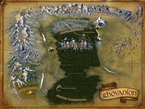
Click for larger image
Region: Eryn Lasgalen 
Area: Felegoth 
Bearded Minstrel Deed location map 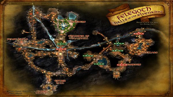
Bearded Minstrel Deed location map - Felegoth 
Bearded Minstrel Deed Location map - Erebor
Page Links
- User:Magill/Sandbox-U22 - Notes
- User:Magill/Sandbox-U22 - Maps - for maps and details on map issues - Strongholds of the North
- Lotro-Wiki.com:Mordor - project Mordor
- Lotro-Wiki.com:Strongholds of the North - project Strongholds of the North - U22
- https://forums-old.lotro.com/forums/showthread.php?661964-Strongholds-of-the-North-Deeds - Thread: Strongholds of the North Deeds
- https://forums-old.lotro.com/forums/showthread.php?654970-Mordor-explorer-deeds/page3 - Thread: Mordor explorer deeds
- Update 22 - Legacy of the Necromancer - March 6, 2018 - patch notes
- Strongholds of the North
- Legacy of the Necromancer
Category overview
Category Strongholds of the North not found
Naming
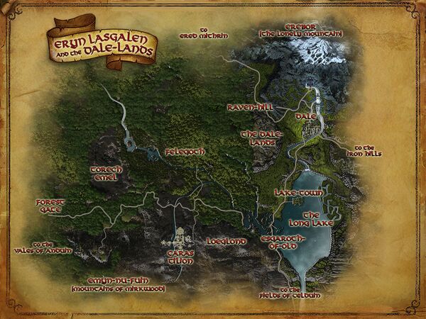
- Until it goes live on Tuesday 3/6, it appears that we won't have any real idea what SSG considers the NAMES to be for the Region and Areas. There appears to be only one top-level map which is labeled "Eryn Lasgalen and the Dale-Lands." At least as of build 3, there are no "sub-maps" -- only one "town map for Felegoth. As you wander around the map, there are clearly Zones (name changes under the Radar), but they are not reflected in most of anything else. Just "one-shot" changes. Dale, Erebor and Laketown being apparently only settlements, not areas. And, of course, the Top-level has been called Northern Mirkwood by everyone BEFORE the Bullroare session began and the Relase notes started calling it "Strongholds of the North". . . obviously (to me at least) because Mirkwood is no more as the in-game timing for this update implies -- after the fall of Dol Guldur.
- All of that said, there is probably a new map of Rhovanion (see below). That map shows a number of previously un-named areas.
- Gundabad
- Upper Anduin
- Beorning-lands
- Gladden Fields
- Ered Mithrin (Grey Mountains)
- Eryn Lasgalen (North Mirkwood)
- Caras Tilion
- Emyn-nu-Fuin (Mountains of Mirkwood)
- Rhosgobel
- The Narrows
- East Bight
- The Withered Heath
- Iron Hills
Mapping Tools
- User:Eleazaros/coords.js -- Javascript code page for adding map coordinates
- User_talk:Eleazaros/coords.js -- Test page for Javascript code page for adding map coordinates
To Do
- Compare Vales of Anduin coordinates with Eryn Lasgalen - see if they moved.
- Rename Eryn Lasgalen and the Dale Lands map to Eryn Lasgalen map
- Compare coordinates (if any) of old Rhovanion map with the new one.
Rhovanion
- There appear to be only 2 landscape mpas - Eryn Lasgalen and Felegoth.
- As of build 3, there is only one interior map - Erebor - but no coordinates are displayed in the interior
Strongholds of the North - Update 22
| Zone | North-East | South-East | Central | North-West | South-West |
|---|---|---|---|---|---|
| Eryn Lasgalen and the Dale Lands | |||||
| Eryn Lasgalen | NE Corner [37.4N, 14.1W] | SE Corner [5.7N, 14.1W] | Felegoth [20.3N, 36.9W] | NW Corner [37.4N, 56.6W] | SW Corner [5.7N, 56.6W] |
| Felegoth | NE Corner [50.0N, 123.7W] | SE Corner [46.0N, 123.7W] | Chamber of Thrandul [48.3N, 126.7W] | NW Corner [50.0N, 129.0W] | SW Corner [46.0N, 129.0W] |
| Dale | NE Corner [37.1S, 29.3E] | SE Corner [54.6S, 29.3E] | The Great Keep [43.6S, 15.7E] | NW Corner [37.1S, 5.9E] | SW Corner [54.6S, 5.9E] |
| Lake-town | NE Corner [45.0S, 22.7E] | SE Corner [66.9S, 22.7E] | Lake-town [61.7S, 6.0E] | NW Corner [45.0S, 6.5W] | SW Corner [66.9S, 6.5W] |
| Erebor | NE Corner [47.9S, 30.8E] | SE Corner [66.0S, 30.8E] | Campfire [60.9S, 16.0E] | NW Corner [47.9S, 6.7E] | SW Corner [66.0S, 6.7E] |
![[37.1S, 29.3E]](/wiki/File:Dor_Amarth_map.jpg)
![[45.0S, 22.7E]](/wiki/File:Lhingris_map.jpg)
![[47.9S, 30.8E]](/wiki/File:Talath_%C3%9Arui_map.jpg)
Maps

- As of U22 Build 2, it is unclear what the real name of the map above will be. It appears to be a replacement map for the current Rhovanion map (below), however it pops-up when the link to "Beorning-lands" or "Fields of Celduin" is followed.
- If this is new Rhovanion map, verify coordinates

| Regions within the Land of Rhovanion
| ||
|---|---|---|
| Azanulbizar, T.A. 2799 • Elderslade • Ered Mithrin and Withered Heath • Eryn Lasgalen and the Dale-lands • Gundabad • Iron Hills • Lothlórien • Mirkwood • Moria • Vales of Anduin • Wells of Langflood |
Eryn Lasgalen

Dale
Lake-town
Erebor
Felegoth

Bearded Minstrel
- Maps prepared by the Bearded Minstrel.
- Blog: https://thebeardedminstrel.blogspot.com
- Source: Thread: Visual Guide to the Strongholds of the North | The Bearded Minstrel
- https://forums-old.lotro.com/forums/showthread.php?662162-Visual-Guide-to-the-Strongholds-of-the-North-The-Bearded-Minstrel


Arkanur
Data From Bullroarer forum, Arkanur: Thread: https://forums-old.lotro.com/forums/showthread.php?661964-Strongholds-of-the-North-Deeds Maps by Arkanur from the LOTRO Forums LotRO player and Doer of Great Deeds on Sirannon [FR] since August 15, 2011. Officer of the Children of Arda (Les Enfants d'Arda) kinship on Sirannon and Editor on the French Lotro-wiki (Lotro-wiki.fr).